Upcoming events
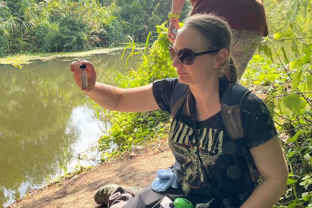
Strandliners is working with four community groups across the Eastbourne, Polegate and Pevensey areas who will act as ‘hubs’ for regular water quality testing by volunteers. The image shows a volunteer using a Hanna checker to test for phosphates in the Langney Sewer.
Demonstrations are being held at each ‘hub’ over the next few weeks, open to everyone. Please come along to see how it works, and decide if you would like to be part of the ongoing project. If you can’t get to a session in your area, come to one of the others – the format will be the same.
Tuesday 24th February – Hampden Park 2 pm
Meet on the lawn in front of the Lakeside tea chalet (What3Words ///pools.sober.snail)
Sunday 1st March – Eastbourne Allotments & Gardens Society 10am
Meet by the shop at Gorringe Road Allotments (What3Words: ///colleague.create.late)
Thursday 12th March – Pevensey & Westham Community Forest Garden – 10 am
Meet at the entrance at Fence Bridge, Wallensend Road, Pevensey Bay
(What3Words: ///vacancies.shams.slanting)
Tuesday 17th March – Next to Brightling Leisure Ground, Polegate – 3 pm
Meet at the William Daly gates, Brightling Road Road
(What3Words: ///aspects.fade.talked)
Tuesday 24th March – Hampden Park 2 pm
Meet on the lawn in front of the Lakeside tea chalet (What3Words ///pools.sober.snail)
Sunday 5th April – Eastbourne Allotments & Gardens Society 10am
Meet by the shop at Gorringe Road Allotments (What3Words: ///colleague.create.late)
Training and equipment provided along with ongoing support from Strandliners. You can download a copy of the results form here and a copy of the testing protocol here.
Results so far can be seen on the Blue Heart Community Map, and on the Water Rangers interactive map.
This project is supported by Blue Heart.
Sunset water testing and bats
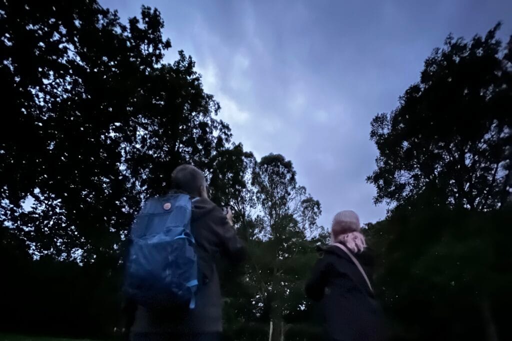
We are bats about water testing! Over the summer months, Strandliners held sunset water testing sessions in both the Eastbourne and Rother Community River Watch areas, bringing along bat detectors to listen out for bats. Here at Hampden Park, there was tension in the air as the sun went down and we waited with bated breath for the bats to emerge. Would we see anything? Watch this video from our YouTube channel to find out…
Museum of Water
Did you collect a sample for the museum of water?
We would love you to tell us the story behind your sample. This could be how you collected the sample, something of the history of the waterbody it came from, or even how the water made you feel. Does that particular water body have any special significance to you? There is no obligation to take part, but we are aiming to make audio recordings of your stories to share at an an event at The View Hotel. Please email if you are interested or would like to find out more.

This project is a collaboration between Strandliners and Compass Art, supported by Blue Heart.
Volunteer ‘water guardians’ were asked to collect a 2-litre sample from their local water body in Eastbourne, Polegate or the Pevensey levels and bring it to The View Hotel in Eastbourne.
19 samples were brought in from sites ranging from dew ponds on the top of the South Downs to lakes in Eastbourne and ditches on allotment sites. The samples were tested by Strandliners for turbidity, total dissolved solids, temperature, ammonia, phosphate, electrical conductivity and pH. Compass Arts then transferred the samples to flasks for display and coded them to correspond with the map display.
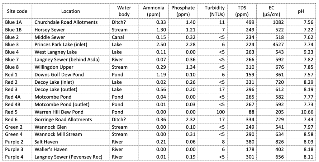
You can also see these results on Blue Heart’s interactive community map. We have to remember this is a snapshot, a moment in time across the catchment, but these samples carry the physical and chemical fingerprints of our local waterways.
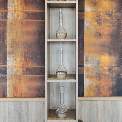
What is a Museum of Water?
It is an installation of water samples, collected by volunteer water guardians, revealing the untold stories of the waterways they came from and the science behind their composition.
How will the water on display change over time? What would cause those changes?
The installation invites us to think about the water around us, something we all need, but often take for granted. It is a collection that invites us to reconsider our relationship with water, how precious it is, and how we might care for it in the future. What feelings does water instil in us: calm, fear, respect, pleasure? How do the waterways feel about us and how we treat them?
We are also looking to collect information connected to these local water courses, so if any of our water guiardinas have any old or new photographs, stories or interesting facts about the water you collected your samples from , we would love to hear from you.
This installation can be seen at The View Hotel, Grand Parade, Eastbourne, BN21 4DN .
There was a Museum of Water in London, which started in 2013 in times of flood, and containing public donations from all over the world. The Museum itself has visited many cultures in many countries. You can explore the collection online and listen to some of the stories from the people who donated the samples.
About Pevensey Levels

Pevensey Levels is a 3,600-hectare biological Site of Special Scientific Interest between Bexhill-on-Sea and Hailsham. It is a Nature Conservation Review site, Grade I, a Ramsar site, and a Special Area of Conservation.
Part of the area is a National Nature Reserve and there is a Pevensey Marshes nature reserve managed by the Sussex Wildlife Trust.
This is a large area of wetland grazing meadows intersected by a network of ditches. It has many nationally rare invertebrates. It may be the best site in Britain for freshwater mollusc fauna, including the endangered shining ram’s-horn snail. It also has one nationally rare and several nationally scarce aquatic plants, and it is of national importance for lapwing.